Key Aims
The Thai-coast project has three key aims:
- Enhance coastal community resilience and future sustainability under climate change scenarios (Work Packages 5 and 6).
- Use the quantitative links developed in WPs 1 and 2 to assess the interaction of natural and social processes under current and future climate change (Work Packages 3, 4, 5).
- Establish quantitative links between climate change, coastal erosion and flooding (Work Packages 1 and 2).
In addressing these three key aims, the project seeks to answer a series of overarching research questions in relation to hydro-meteorological hazards’ impact and coastal community resilience:
- What are the quantitative links between climate change, coastal erosion and flooding? (addressed in Work Packages 1 and 2)
- To what extent do river catchment processes influence coastal erosion and flooding? (addressed in Work Packages 1 and 2)
- How do natural and social processes interact to exacerbate or mitigate the impact of hydro-meteorological hazards? (addressed in Work Packages 3 and 4)
- How can the role of governance and institutional arrangements be strengthened to mitigate future impacts of hydro-meteorological hazards on coastal communities in Thailand? (addressed in Work Packages 5 and 6)
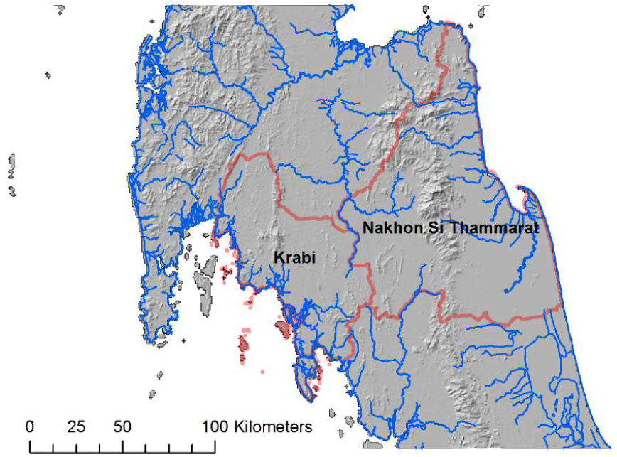
Study Areas
The research focuses on two study areas, Nakhon Si Thammarat province and Krabi province, selected on the basis of DMCR coastal erosion data and with contrasting natural and socio-economic characteristics (Table 1). This enables us to apply identical, in-depth methodologies to facilitate direct comparison of two contrasting sites and to establish policy-relevant research outcomes of value to other coastal provinces after project completion.
| Coastal characteristics / Province | Nakhon Si Thammarat | Krabi | |
|---|---|---|---|
| Costal distance (km) | 244.99 | 216.31 | |
| Coastal erosion (km) | 53.46 | 39.20 | |
| Coastal erosion (%) | 21.82 | 18.12 | |
| Level of coastal erosion (km) | > 5 m/yr | 18.87 | 4.80 |
| 1-5 m/yr | 17.53 | 34.40 | |
| < 1 m/yr | 17.06 | 0 | |
Table 1a.
| Study site | Nakhon Si Thammarat province | Krabi province |
|---|---|---|
| Location | East coast, Gulf of Thailand | Andaman coast |
| Tidal regime | 0.2 – 1.2m | 2.5 – 3.0m (max. 4.0m) |
| Dominant wave direction | S-SE | S-SW |
| Significant wave height | 1 – 2m | 0.3 – 1.5m |
| Annual average rainfall | 2292 mm (> 750mm November, December) | 2388mm (max. 6606 mm during SW monsoon, May to August) |
| Area | 9,942km² | 4,709 km² |
| Dominant geology | Igneous, granite | Sedimentary, limestone |
| Main river catchment | Tapi River (235 km long; catchment area 5,460 km²) | Khlong Krabi Yai (36 km long; catchment area 198 km²) |
| Conservation designation | Khao Luang National Park | Krabi river estuary is registered Ramsar site since 2001 |
| Dominant human economic activities | Aquaculture; agriculture | Tourism |
| Population density | 159 / km² | 97 / km² |
| Total population | 1,548,000 | 456,811 |
Table 1b.
Table 1. Thai-coast project study areas (a) Location, topography, rivers and level of coastal erosion. (b) Key natural and social characteristics (source: DMRC, 2009, 2016).